No PCT miles today.
Clouds & distant lightning rolled in during the night. We see sleeping on a ground lava-rock frontage driveway next to the highway. Good sleep, nevertheless.
Trail Angel Lloyd Gust transported us to Sisters. Resupplying and eating and laundry and beer!!
- Posted using BlogPress from my iPhone
Saturday, August 18, 2012

Friday, August 17, 2012
17 August - Day 116 - Out of the woods and into mountain glory
From Koosah Mountain (Mile 1965) to McKenzie Pass (Mile 1989.5)
Total PCT Miles hiked today: 24.5
Total miles hiked today: 26
Dionysus here.
What views as we hiked past all three Sisters today -
And then saw to the north the extinct volcanoes of Mt Washington, Three-fingered Jack, and slumbering snowy Mt Jefferson -- all pointy & peaky, like a Tolkien sketch of the Lonely Mountain.
In and out of lava fields, glacier melt creeks and glissadable snow fields. We passed through about two miles in which black glassy obsidian covered everything - it was in the creeks and waterfalls, the high cliff faces above the trail, we were walking on it for the gods' sake.
Later as we were approaching the end of the day we ran into some trail magic as we went for water. Pocahontas and Leg-o-saurus, who hiked in 96, were set up in a campsite making dinner for hikers. I got grilled cheese, chili, all the hostess snacks I could stuff in my mouth and fresh delicious watermelon. We sang for them as a thank you, they loved it (and videotaped it for YouTube!?) almost as much as we loved their magic. Thanks again you two.
We had grand plans of hiking on from there another big chunk but instead we hiked a couple miles to the road through a lava field, arrived as night set in, saw the lava stretched a ways more and called it. It was a wild and wacky camp site off the side of the road in the only flat spots in the whole black pumice filled crater. I slept well though, despite the cars driving by and the great light-show of a thunderstorm to the west in the early hours.
- Posted using BlogPress from my iPhone
Total PCT Miles hiked today: 24.5
Total miles hiked today: 26
Dionysus here.
What views as we hiked past all three Sisters today -
And then saw to the north the extinct volcanoes of Mt Washington, Three-fingered Jack, and slumbering snowy Mt Jefferson -- all pointy & peaky, like a Tolkien sketch of the Lonely Mountain.
In and out of lava fields, glacier melt creeks and glissadable snow fields. We passed through about two miles in which black glassy obsidian covered everything - it was in the creeks and waterfalls, the high cliff faces above the trail, we were walking on it for the gods' sake.
Later as we were approaching the end of the day we ran into some trail magic as we went for water. Pocahontas and Leg-o-saurus, who hiked in 96, were set up in a campsite making dinner for hikers. I got grilled cheese, chili, all the hostess snacks I could stuff in my mouth and fresh delicious watermelon. We sang for them as a thank you, they loved it (and videotaped it for YouTube!?) almost as much as we loved their magic. Thanks again you two.
We had grand plans of hiking on from there another big chunk but instead we hiked a couple miles to the road through a lava field, arrived as night set in, saw the lava stretched a ways more and called it. It was a wild and wacky camp site off the side of the road in the only flat spots in the whole black pumice filled crater. I slept well though, despite the cars driving by and the great light-show of a thunderstorm to the west in the early hours.
- Posted using BlogPress from my iPhone


Thursday, August 16, 2012
16 August - Day 115 - Marathon between fires
From Taylor Lake (Mile 1936.8) to Koosah Mountain (Mile 1965)
Total PCT Miles Hiked Today: 28.2
Pan here.
Behind us, the fires are keeping PCT hikers from entering this section. Ahead, at mile 2044 there's a 21-mile reroute to detour around a out 10 miles of PCT trail that's closed from the Ollalie fire. Yuck.
But we have to get to Sisters day after tomorrow - and manage the 15-mile hitch both ways - to resupply and hop back on the trail. We hope to reach Cascade Locks on the Oregon/Washington border by Aug. 24, a week from tomorrow. So we zooooomed today (ouch) and made 28+ miles by 6pm. Woah! That's more like our pre-Ashland mileage. [ever since my 4-day bout with fever and diarrhea, I've been just able to grind out 20 miles: my feet have gotten thin and bony].
 Quiet weather today, as usual. And the sunlight coming through the trees remained tinged with rose-orange all day. The sky is thinly washed in smoke.
Now we're sitting pretty atop the cone of Koosah Mountain, where thru-hikers have cleared the lava rock so two tents can just fit, with panoramic views from west around to southeast. The Cascades roll in blue-shaded layers in all directions - with cone shapes predominating. To the east is the snow-streaked volcano, Bachelor Peak. To the northeast is the southernmost of the Three Sisters -- much higher with considerably more snow. We see lakes tucked in the folds of the wooded mountains down below. But all is silent here. And the sun is going down a hot tangerine color.
We should have good stars tonight - and more shooting stars like last night.
PS. On a somber note, yesterday we stopped by Charlton Lake to pay our respects to AsABat, the veteran PCT hiker whose body was discovered here last week. He was a year younger than I, and apparently died of natural causes. He contributed so much energy and creativity to the PCT and will be sorely missed.
- Posted using BlogPress from my iPhone
Total PCT Miles Hiked Today: 28.2
Pan here.
 |
| Sunrise from our campsite at Taylor Lake. |
But we have to get to Sisters day after tomorrow - and manage the 15-mile hitch both ways - to resupply and hop back on the trail. We hope to reach Cascade Locks on the Oregon/Washington border by Aug. 24, a week from tomorrow. So we zooooomed today (ouch) and made 28+ miles by 6pm. Woah! That's more like our pre-Ashland mileage. [ever since my 4-day bout with fever and diarrhea, I've been just able to grind out 20 miles: my feet have gotten thin and bony].
Quiet weather today, as usual. And the sunlight coming through the trees remained tinged with rose-orange all day. The sky is thinly washed in smoke. Now we're sitting pretty atop the cone of Koosah Mountain, where thru-hikers have cleared the lava rock so two tents can just fit, with panoramic views from west around to southeast. The Cascades roll in blue-shaded layers in all directions - with cone shapes predominating. To the east is the snow-streaked volcano, Bachelor Peak. To the northeast is the southernmost of the Three Sisters -- much higher with considerably more snow. We see lakes tucked in the folds of the wooded mountains down below. But all is silent here. And the sun is going down a hot tangerine color.
We should have good stars tonight - and more shooting stars like last night.
PS. On a somber note, yesterday we stopped by Charlton Lake to pay our respects to AsABat, the veteran PCT hiker whose body was discovered here last week. He was a year younger than I, and apparently died of natural causes. He contributed so much energy and creativity to the PCT and will be sorely missed.
- Posted using BlogPress from my iPhone
Wednesday, August 15, 2012
15 August - Day 114 - FIRE! And Silence Falls on the Summer Woods
From Lower Rosary Lake (Mile 1917.3) to Taylor Lake (Mile 1936.5)
Total PCT Miles Hiked Today: 19.2
We'll post this entry out of sequence - then post the earlier journal entries as we can.
Fires have sprung up in Oregon ever more aggressively. Counting all the fires in California (I won't list them here) this could well be the worst fire season for the PCT in memory. Behind us trail closures due to fire have stranded or caused major problems for PCT Hikers. The Chips fire at Belden. The Reading Fire in Lassen National Park. The Fort Complex fire north of the Seiad Valley. More fires just behind us on Mt Thielsen ... Trails we walked two days ago are closed now due to fire. And hot spots keep flaring up not far away. Ahead of us 100 miles (4-5 days hiking) the PCT is closed from a fire near Mt Jefferson. We'll have to reroute. Argh. The sky at sunrise is the rose of ash and smoke.
Morning lakeside logistics after breakfast today. We had some iPhone madness - posting online orders for all the last gear and logistical items we anticipate needing for WA. We are planning a big shop-em-up-&-box-em-up marathon zero day in Cascade Locks where we will put together all of our resupply boxes for the rest of the trip. From then on it will be smooth sailing (we hope) as we stop just long enough to dry off (if it ever rains) and pick up our boxes before we are on our way again.
Strange silences in the forest all day today. Its like the land has turned the corner toward Autumn and everything has started conserving its energy for winter. No bird song. No animals. No bug sound. The air wasn't moving. Just still. Kind of eerie and unsettling. One positive side effect is that there were sharply fewer mozzies (we are looking forward to the day they leave forever - we hear that sometime soon someone hits the off switch).


A beautiful if monotonous hike through mossy green hallways of fir-hemlock forest for most of the day. Then at the end of the hike the forest walls fell down around us when we entered an old burn area and, voilà! the Three Sisters (and perhaps some other volcanic mountains) filling the horizon to the north.
- Posted using BlogPress from my iPhone
Total PCT Miles Hiked Today: 19.2
We'll post this entry out of sequence - then post the earlier journal entries as we can.
Fires have sprung up in Oregon ever more aggressively. Counting all the fires in California (I won't list them here) this could well be the worst fire season for the PCT in memory. Behind us trail closures due to fire have stranded or caused major problems for PCT Hikers. The Chips fire at Belden. The Reading Fire in Lassen National Park. The Fort Complex fire north of the Seiad Valley. More fires just behind us on Mt Thielsen ... Trails we walked two days ago are closed now due to fire. And hot spots keep flaring up not far away. Ahead of us 100 miles (4-5 days hiking) the PCT is closed from a fire near Mt Jefferson. We'll have to reroute. Argh. The sky at sunrise is the rose of ash and smoke.
Morning lakeside logistics after breakfast today. We had some iPhone madness - posting online orders for all the last gear and logistical items we anticipate needing for WA. We are planning a big shop-em-up-&-box-em-up marathon zero day in Cascade Locks where we will put together all of our resupply boxes for the rest of the trip. From then on it will be smooth sailing (we hope) as we stop just long enough to dry off (if it ever rains) and pick up our boxes before we are on our way again.
Strange silences in the forest all day today. Its like the land has turned the corner toward Autumn and everything has started conserving its energy for winter. No bird song. No animals. No bug sound. The air wasn't moving. Just still. Kind of eerie and unsettling. One positive side effect is that there were sharply fewer mozzies (we are looking forward to the day they leave forever - we hear that sometime soon someone hits the off switch).


A beautiful if monotonous hike through mossy green hallways of fir-hemlock forest for most of the day. Then at the end of the hike the forest walls fell down around us when we entered an old burn area and, voilà! the Three Sisters (and perhaps some other volcanic mountains) filling the horizon to the north.
- Posted using BlogPress from my iPhone
Tuesday, August 14, 2012
14 August - Day 113 - Lakeside interlude between green shaggy forests
From Crescent Lake Campground (alternate mile 8.9) to Lower Rosary Lake (Mile 1917.3)
Total Miles Hiked: 18
Dionysus here.
Woke this morning at our beautiful campground at Crescent Lake and set out for a 12-mile hike to Shelter Cove Resort, where we can do laundry, showers, and we have a resupply box waiting for us. Finding the proper trail out of the campground was a trick. But after wandering around for an hour or so on roads and trails which only partially conformed to our maps we finally found the trail we needed.
We wound around through a series of small lakes and argued with the über dusty track and persistent bugs the whole way. Then about a mile out from the cove we dropped into a lovely creek valley and the track turned to soft pack duff the mozzies disappeared and the trees and understory filled with moss and vibrant green lichen. What a surprising and abrupt change in what has been a very consistent forest landscape.
It was so good to shower at Shelter Cove! The water only turned on for three minute intervals, so you had to be really quick about it, but gods! to be clean again! We did all our logistics pretty quickly then waited for electronics to charge over a few beers and microwaved queso dip. It was heaven, but it made getting up to leave rather more difficult.
When we finally pried free from the vortex there, we made a short few miles and set up camp at beautiful Rosary Lake. A nice easy day.
- Posted using BlogPress from my iPhone
Total Miles Hiked: 18
Dionysus here.
Woke this morning at our beautiful campground at Crescent Lake and set out for a 12-mile hike to Shelter Cove Resort, where we can do laundry, showers, and we have a resupply box waiting for us. Finding the proper trail out of the campground was a trick. But after wandering around for an hour or so on roads and trails which only partially conformed to our maps we finally found the trail we needed.
We wound around through a series of small lakes and argued with the über dusty track and persistent bugs the whole way. Then about a mile out from the cove we dropped into a lovely creek valley and the track turned to soft pack duff the mozzies disappeared and the trees and understory filled with moss and vibrant green lichen. What a surprising and abrupt change in what has been a very consistent forest landscape.
It was so good to shower at Shelter Cove! The water only turned on for three minute intervals, so you had to be really quick about it, but gods! to be clean again! We did all our logistics pretty quickly then waited for electronics to charge over a few beers and microwaved queso dip. It was heaven, but it made getting up to leave rather more difficult.
When we finally pried free from the vortex there, we made a short few miles and set up camp at beautiful Rosary Lake. A nice easy day.
- Posted using BlogPress from my iPhone
Monday, August 13, 2012
13 August - Day 112 - Trail Magic & then a beach
From Maidu Lake (Mile 1871.3) to Windigo Pass on Forest Rd 60 (Mile 1884) to Crescent Lake Campground (alternate mile 8.9)
Total PCT Miles + alternate hiked today: 21.6
As we hiked up to Forest Rd 60, we were delighted to meet Steady, a thru-hiker from Tulsa and her husband doling out trail magic from their pickup. Subway sandwiches, cold sodas, chips, cookies, brownies and more!! Wowie! We thought w had left trail magic behind ~~ what a gracious and generous pair. The three of us sang "O Shenandoah" by way of saying thank you, and our hosts were pleased.
We hiked the hot and dusty alternate route, and eventually got to Crescent Lake campground -- an RV campground with a beach on the lake. Several other thru-hikers stayed here.
While we ate, helicopters came zooming in at the lake with firefighting buckets hanging from them. They dipped them into the lake and flew off -- but not far. We could see smoke in the woods not more than a couple of miles away.
After dinner, Dionysus and I joined Tony, a Belgian thru-hiker, in swimming in the lake. Sooooo refreshing -- and an apt substitute for a bath.
The night closed with he three of us laughing aloud over and over from our sleeping bags as we read our respective Pratchett novels.
Nice.
PS. We camped among RVs -- not our first time. And we've tentatively come up with what seems to us to be a corollary. There seems to be an inverse relationship between the size of the US flag an RV camper hangs from his portable flagpole, and general friendliness. The bigger the flag, the greater the likelihood the camper will be surly and hostile. At least toward hikers.
- Posted using BlogPress from my iPhone
Total PCT Miles + alternate hiked today: 21.6
As we hiked up to Forest Rd 60, we were delighted to meet Steady, a thru-hiker from Tulsa and her husband doling out trail magic from their pickup. Subway sandwiches, cold sodas, chips, cookies, brownies and more!! Wowie! We thought w had left trail magic behind ~~ what a gracious and generous pair. The three of us sang "O Shenandoah" by way of saying thank you, and our hosts were pleased.
We hiked the hot and dusty alternate route, and eventually got to Crescent Lake campground -- an RV campground with a beach on the lake. Several other thru-hikers stayed here.
While we ate, helicopters came zooming in at the lake with firefighting buckets hanging from them. They dipped them into the lake and flew off -- but not far. We could see smoke in the woods not more than a couple of miles away.
After dinner, Dionysus and I joined Tony, a Belgian thru-hiker, in swimming in the lake. Sooooo refreshing -- and an apt substitute for a bath.
The night closed with he three of us laughing aloud over and over from our sleeping bags as we read our respective Pratchett novels.
Nice.
PS. We camped among RVs -- not our first time. And we've tentatively come up with what seems to us to be a corollary. There seems to be an inverse relationship between the size of the US flag an RV camper hangs from his portable flagpole, and general friendliness. The bigger the flag, the greater the likelihood the camper will be surly and hostile. At least toward hikers.
- Posted using BlogPress from my iPhone
Sunday, August 12, 2012
Aug. 12 - Day 111 - the dry Cascades
From cowboy camp (Mile 1848) to Maidu Lake (Mile 1871.3)
PCT Miles today: 23.3
Up across Highway 138 today -- continuing through flat pine forests. Then we get glimpses of Mt. Thielsen in the distance -- and old rotted out volcano, whose hardened magma core still sticks up like fingers from its crumbly sides. We were hiking thirsty, since our mishap with the poisoned water cache. Diamond Lake passed off to our left, but we made no detours for its town-food pleasures.
On and up Mt. Thielsen -- beautiful, beautiful Mt. Thielsen.
But water was scarce, and we grew very thirsty until we finally reached Thielsen Creek at 1861.4. after 13 miles of thirsty hiking. Oh, what incredibly cold freshness. What a delicious creek. And it's a hot bright day.

We bathed our feet -- (they turned livid pink in the ice water melt). We drank ate, and drank some more. We met a south-bounder here who chatted with us about conditions up ahead.
On and on north, until finally we took the detour to Maidu Lake where other thru-hikers (Chris from Philly, Shutterbug from Portland, and others) were camped. We were too exhausted to be good company, so set up our tents (such mosquitoes, ugh) off to the right of the trail nestled in among hemlocks.
We sat by the lake on a log and made our noodles for supper. The lake was gorgeous ... but soon we were tucked into our tents away from the mozzies (no rainflies) and reading Terry Pratchett and laughing and laughing (Dionysus's laughter triggers Sean and mine). Hilarious and a happy end to a beautiful hard day.
G'night.
PS. Some days later, after we had left these lovely mountains, another wildfire broke out -- this time near Mt. Thielsen -- and soon the PCT on Mt. Thielsen was closed off. Fires followed us about a week behind on north.
PCT Miles today: 23.3
Up across Highway 138 today -- continuing through flat pine forests. Then we get glimpses of Mt. Thielsen in the distance -- and old rotted out volcano, whose hardened magma core still sticks up like fingers from its crumbly sides. We were hiking thirsty, since our mishap with the poisoned water cache. Diamond Lake passed off to our left, but we made no detours for its town-food pleasures.
On and up Mt. Thielsen -- beautiful, beautiful Mt. Thielsen.
 |
| Dionysus at Mt. Thielsen. Smoke haze is still following us from the south. |
 |
| Pan on the trail heading toward a snow field. |
 |
| The view back toward Diamond Peak. |
But water was scarce, and we grew very thirsty until we finally reached Thielsen Creek at 1861.4. after 13 miles of thirsty hiking. Oh, what incredibly cold freshness. What a delicious creek. And it's a hot bright day.
 |
| Blessed Thielsen Creek! |

We bathed our feet -- (they turned livid pink in the ice water melt). We drank ate, and drank some more. We met a south-bounder here who chatted with us about conditions up ahead.
On and on north, until finally we took the detour to Maidu Lake where other thru-hikers (Chris from Philly, Shutterbug from Portland, and others) were camped. We were too exhausted to be good company, so set up our tents (such mosquitoes, ugh) off to the right of the trail nestled in among hemlocks.
We sat by the lake on a log and made our noodles for supper. The lake was gorgeous ... but soon we were tucked into our tents away from the mozzies (no rainflies) and reading Terry Pratchett and laughing and laughing (Dionysus's laughter triggers Sean and mine). Hilarious and a happy end to a beautiful hard day.
G'night.
PS. Some days later, after we had left these lovely mountains, another wildfire broke out -- this time near Mt. Thielsen -- and soon the PCT on Mt. Thielsen was closed off. Fires followed us about a week behind on north.
Saturday, August 11, 2012
Aug 11, 2012 - Day 110 - The smoky Rim of Crater Lake
From Mazama Village Campground at Crater Lake (Mile 1830.6) to cowboy camp (Mile 1848)
PCT Miles: 18
We were a little slow getting out of the campground at Mazama -- probably on the trail by 7.30 -- and then up to the Rim. But no views there. Smoke from wildfires to the east and south were obscuring the world-famous clarity of the lake views. At times we could see across to the other rim.
We ate at the grand old Crater Lake Lodge on the Rim. Really good breakfast, despite other thru-hikers grousing about the prices. Hey, where else can you get food this good here? It was great.
Then onto the PCT trail hugging the rim of the crater. Uff. Up and down and up and up and down. What a workout for our weary legs. And always the traffic of vacationers to our left -- and the flowery-scented tourists bounding eagerly past us in white white clothes. We grinned.
Eventually our path took us off and to the north across long flats covered in lodgepole pine. Lodgepole doesn't do well here. It falls over a lot. The forest was a maze of standing and fallen trees we had to step over. And step over. And step over.
A cache of water was indicated across Highway 209 off to the west on the equestrian PCT where it intersected with our trail. We headed over to have supper there. Beware!!! One sip we had from the water we poured from the cache was scorchingly full of chlorine. Burned our lips, nostrils, and throats. Ugh!!! Wonder what the deal was? We didn't discover the problem, however, until we reached our campsite for the night ... too late. We had to go without water.
PCT Miles: 18
We were a little slow getting out of the campground at Mazama -- probably on the trail by 7.30 -- and then up to the Rim. But no views there. Smoke from wildfires to the east and south were obscuring the world-famous clarity of the lake views. At times we could see across to the other rim.
 |
| Seano mugging for the camera. :-) |
 |
| The view before the smoke totally closed it off. |
We ate at the grand old Crater Lake Lodge on the Rim. Really good breakfast, despite other thru-hikers grousing about the prices. Hey, where else can you get food this good here? It was great.
Then onto the PCT trail hugging the rim of the crater. Uff. Up and down and up and up and down. What a workout for our weary legs. And always the traffic of vacationers to our left -- and the flowery-scented tourists bounding eagerly past us in white white clothes. We grinned.
Eventually our path took us off and to the north across long flats covered in lodgepole pine. Lodgepole doesn't do well here. It falls over a lot. The forest was a maze of standing and fallen trees we had to step over. And step over. And step over.
A cache of water was indicated across Highway 209 off to the west on the equestrian PCT where it intersected with our trail. We headed over to have supper there. Beware!!! One sip we had from the water we poured from the cache was scorchingly full of chlorine. Burned our lips, nostrils, and throats. Ugh!!! Wonder what the deal was? We didn't discover the problem, however, until we reached our campsite for the night ... too late. We had to go without water.
Photos
Here Are some photos from the last few days.
 |
| Happy Ashland moment from a few days ago, of Dionysus and his parents, holding his diploma from the University of Colorado at Boulder, and his magna-cum-laude medal. Yay!! |
Posted using BlogPress from my iPhone
Friday, August 10, 2012
10 Aug - Day 109 - Twenty to lunch.
From flat space among firs beside trail beyond Honeymoon Creek (Mile 1810.6) to Mazama Village Campground at Crater Lake (Mile 1830.6)
Total PCT Miles Hiked Today: 20
On and on -- the morning we passed through a large burn.
By 1 o'clock in the afternoon we banged out 20 miles -- much to the outrage of our feet. But we were out of food and could hear in our imaginations the "all you can eat" buffet at the restaurant in Mazama Village calling us. As it turned out, no more AYCE buffets there. But the beer came in a very civilized 23 oz glasses, so we made up for sore feet by imbibing. [Why we never remember to take photos of our plates and restaurants is a testament to our feverish chowing-down. But ooooh, how we should have photographed the meals. They meant so much to us. Every time!]
The campground was full which would mean we'd have more miles of trail taking us away from laundry and showers. Two unimaginative assistant managers confirmed we were must emphatically out of luck. But I took the manager aside, and we had a very congenial conversation, and soon he found us a beautiful spacious campsite. [My students at the university call this my "Jedi mind trick." It's just good rhetoric, really.]
I showered -- with Tide detergent as my soap, no less -- then headed to the laundry, while Dionysus and Seano set up camp and got their resupply boxes.
Rest and eating, and rest and eating, and rest and eating the rest of the day. We'll get up to the rim tomorrow - it's 5 miles from here. Tomorrow we'll be hiking right along the rim with vews, views, views. Seems to be smoke on the horizon. Is there a fire nearby?
- Posted using BlogPress from my iPhone
Total PCT Miles Hiked Today: 20
On and on -- the morning we passed through a large burn.
 |
| You can see the beginning regeneration. But it baffled us why so many thru-hikers kept having campfires night after night, when they didn't need them, and when the landscape behind us was burning ... and this scarred landscape was not unusual. |
 |
| Mini-fir. |
 |
| Hiking through. |
 |
| Fireweed adding color to the silvery-white trunks. |
By 1 o'clock in the afternoon we banged out 20 miles -- much to the outrage of our feet. But we were out of food and could hear in our imaginations the "all you can eat" buffet at the restaurant in Mazama Village calling us. As it turned out, no more AYCE buffets there. But the beer came in a very civilized 23 oz glasses, so we made up for sore feet by imbibing. [Why we never remember to take photos of our plates and restaurants is a testament to our feverish chowing-down. But ooooh, how we should have photographed the meals. They meant so much to us. Every time!]
The campground was full which would mean we'd have more miles of trail taking us away from laundry and showers. Two unimaginative assistant managers confirmed we were must emphatically out of luck. But I took the manager aside, and we had a very congenial conversation, and soon he found us a beautiful spacious campsite. [My students at the university call this my "Jedi mind trick." It's just good rhetoric, really.]
I showered -- with Tide detergent as my soap, no less -- then headed to the laundry, while Dionysus and Seano set up camp and got their resupply boxes.
Rest and eating, and rest and eating, and rest and eating the rest of the day. We'll get up to the rim tomorrow - it's 5 miles from here. Tomorrow we'll be hiking right along the rim with vews, views, views. Seems to be smoke on the horizon. Is there a fire nearby?
- Posted using BlogPress from my iPhone
Thursday, August 9, 2012
9 Aug - Day 108 - Volcanoes
!From creek beside Highway 104 (Mile 1780.6) to flat space among firs beside trail beyond Honeymoon Creek (Mile 1810.6)
Total PCT Miles Hiked today: 30
Pan here.
Last views of Shasta, beautiful east and north views of Mt McLaughlin, views of Crater Lake, and in the great distance beyond many cone-shaped mountains, extinct Mt Thielsen.

Long miles through relatively even terrain in the fir forest atop the Cascsdes. Then toward the last third, several climbs onto sheer volcanic rim slopes with outstanding views.
Last two days our feet have been hurting -- that is, more than is usual. But today we girded our dusty loins for a big day, since we needed to get lots closer to Crater Lake. So it was a lonnnng day.
We feel we are less strong than we were in the Sierras (Seano and I, that is; Dionysus may well be as strong as ever). We hear this from other thru-hikers -- especially the veterans of the PCT. We seem to be wearing thinner -- or leaner. We walk on feet becoming bony. We arrive at national park campgrounds not walking tall and mighty, strapping thru-hikers with muscles of iron. We shamble in like refugees or prisoners of war. Yes, our legs are strong -- but strong like jerky or like the scrawny wiry legs of free-range chickens. Poor eatin' on them legs.
Passed 1800 mile mark! How these hundred-mile markers seem to speed by now.

On the trail today we met Chris from Philly, who was a real pleasure to visit with. Intelligent conversation about many things other than gear and food. (Yay). When we introduced ourselves as the 3 Gay Caballeros, he chuckled and said: "At last I get to meet you. I've been hearing about you for a thousand miles." [It's not the first time thru-hikers have told us that ... and we always are shocked. Why would anyone "hear" about us? We feel to be pretty dull hikers.]
We hike into the dark, and set up tents while getting zinged and re-zinged by mosquitoes. Ugh. We all collapse into sleeping bags pretty worn out.
Tomorrow: a 20-mile sprint into Mazama Campground at Crater Lake. (My aching feet!)
- Posted using BlogPress from my iPhone
Total PCT Miles Hiked today: 30
Pan here.
Last views of Shasta, beautiful east and north views of Mt McLaughlin, views of Crater Lake, and in the great distance beyond many cone-shaped mountains, extinct Mt Thielsen.

Long miles through relatively even terrain in the fir forest atop the Cascsdes. Then toward the last third, several climbs onto sheer volcanic rim slopes with outstanding views.
Last two days our feet have been hurting -- that is, more than is usual. But today we girded our dusty loins for a big day, since we needed to get lots closer to Crater Lake. So it was a lonnnng day.
We feel we are less strong than we were in the Sierras (Seano and I, that is; Dionysus may well be as strong as ever). We hear this from other thru-hikers -- especially the veterans of the PCT. We seem to be wearing thinner -- or leaner. We walk on feet becoming bony. We arrive at national park campgrounds not walking tall and mighty, strapping thru-hikers with muscles of iron. We shamble in like refugees or prisoners of war. Yes, our legs are strong -- but strong like jerky or like the scrawny wiry legs of free-range chickens. Poor eatin' on them legs.
Passed 1800 mile mark! How these hundred-mile markers seem to speed by now.

On the trail today we met Chris from Philly, who was a real pleasure to visit with. Intelligent conversation about many things other than gear and food. (Yay). When we introduced ourselves as the 3 Gay Caballeros, he chuckled and said: "At last I get to meet you. I've been hearing about you for a thousand miles." [It's not the first time thru-hikers have told us that ... and we always are shocked. Why would anyone "hear" about us? We feel to be pretty dull hikers.]
We hike into the dark, and set up tents while getting zinged and re-zinged by mosquitoes. Ugh. We all collapse into sleeping bags pretty worn out.
Tomorrow: a 20-mile sprint into Mazama Campground at Crater Lake. (My aching feet!)
- Posted using BlogPress from my iPhone
Wednesday, August 8, 2012
8 Aug - Day 107 - Deeper firs
From Klum Landing Campground on Howard Prairie Reservoir (Mile 1758) to creek beside Highway 104 (Mile 1780.6)
Total PCT Miles today: 22.6
Pan here.
Of seven species of fir native to the western US, Oregon has six. And we've seen them all. Now we have the on-trail fun of identifying Pacific Silver Fir and Noble Fir, and keeping them distinct from our White Fir, Grand Fir, and California Red Fir.
Today we pushed on northwards toward the sharp cone of Mt McLaughlin. We passed out of deep woods with our first huckleberries (yum!) and out onto slopes and hillsides of basalt boulders with nothing growing but chinquapin. We passes through the landscape on a carefully groomed red lava rock path. (thank you, PCTA!)
Still no mosquitoes to speak of .. . But we hear that changes near Crater Lake.
We hiked hard and fast to try to make Fish Lake Campground and restaurant -- but couldn't get a ride on Hwy 140. The restaurant closed. So we camped off the road in the deep woods by a roaring creek. Nice, since water availability has been more spotty, for all the deep green woods we bike through.
Bad reception so no pics can be loaded. Shucks.
- Posted using BlogPress from my iPhone
Total PCT Miles today: 22.6
Pan here.
Of seven species of fir native to the western US, Oregon has six. And we've seen them all. Now we have the on-trail fun of identifying Pacific Silver Fir and Noble Fir, and keeping them distinct from our White Fir, Grand Fir, and California Red Fir.
Today we pushed on northwards toward the sharp cone of Mt McLaughlin. We passed out of deep woods with our first huckleberries (yum!) and out onto slopes and hillsides of basalt boulders with nothing growing but chinquapin. We passes through the landscape on a carefully groomed red lava rock path. (thank you, PCTA!)
Still no mosquitoes to speak of .. . But we hear that changes near Crater Lake.
We hiked hard and fast to try to make Fish Lake Campground and restaurant -- but couldn't get a ride on Hwy 140. The restaurant closed. So we camped off the road in the deep woods by a roaring creek. Nice, since water availability has been more spotty, for all the deep green woods we bike through.
Bad reception so no pics can be loaded. Shucks.
- Posted using BlogPress from my iPhone
Tuesday, August 7, 2012
7 Aug - Day 106 - Easygoing
From pond and spring (Mile 1738.7) to Klum Landing Campground on Howard Prairie Reservoir (Mile 1758)
Total PCT Miles Hiked Today: 19.3
Dionysus here.
We took it slow and easy today. Despite our several zeros in Ashland we are still feeling tuckered out. Since we had a great campsite we just took our time getting up and out this morning. Our camp overlooked a small pond with birds and dragonflies swooshing over the surface. We took a slow coffee and breakfast over sunrise and traded stories about the crazy coyote activity the night before. (A big group of them was howling in round - an inhuman and uncanny noise.)
We continued our gentle approach to the day by hiking a mile off trail to a little restaurant called the Green Springs Inn. We had late breakfast/lunch there. They made real sourdough hot cakes and served them with real maple syrup! Something we couldn't get in Eastern California. I'm liking Oregon so far.
After getting back on trail we spent the rest of the day skirting the banks of a series of lakes. We finally rested at a beautiful camp on the side of one. We settled in at the picnic table with some tequila for sunset and the glamour on the lake. It was a really great site.
- Posted using BlogPress from my iPhone
Total PCT Miles Hiked Today: 19.3
Dionysus here.
We took it slow and easy today. Despite our several zeros in Ashland we are still feeling tuckered out. Since we had a great campsite we just took our time getting up and out this morning. Our camp overlooked a small pond with birds and dragonflies swooshing over the surface. We took a slow coffee and breakfast over sunrise and traded stories about the crazy coyote activity the night before. (A big group of them was howling in round - an inhuman and uncanny noise.)
 |
| Heading north. |
We continued our gentle approach to the day by hiking a mile off trail to a little restaurant called the Green Springs Inn. We had late breakfast/lunch there. They made real sourdough hot cakes and served them with real maple syrup! Something we couldn't get in Eastern California. I'm liking Oregon so far.
After getting back on trail we spent the rest of the day skirting the banks of a series of lakes. We finally rested at a beautiful camp on the side of one. We settled in at the picnic table with some tequila for sunset and the glamour on the lake. It was a really great site.
- Posted using BlogPress from my iPhone
Monday, August 6, 2012
6 Aug - Day 106 - Embrace of Southern Oregon
From Mt Ashland Campground (Mile 1718.5) to pond and spring (Mile 1738.7)
Total PCT Miles hiked today: 20.2
Back to the trail -- tho this section of the PCT south and then east of Ashland abounds in hiker pit stops (places to get food, drink, or lodging as wished). We cross roads and can hear traffic as we traverse the mountains in an arc around the southern end of the Ashland valley.
We eat lunch (and have our free PCT Hiker beer) at Callahan's Lodge, while watching a bit more of the Olympics. At Callahan's we see 3Bears, whom we have missed since Kennedy Meadows more than 700 miles ago. He seemed pretty wiped out. We also bumped into Pace on the trail who had giardiasis and recuperated for a time in Shasta. He's doing well, tho he indicated the trail was wearing on him. So it is for everyone we talk to these days.
We feel it too in many ways. We do not, however, miss home. We are home together. We want to be here. We want to do this. But it is a work of determination and discipline.
Maybe our relationship with the PCT is like other long-term intimate relationships: we have passed thru the stages of infatuation and unqualified enthusiasm, to disillusionment, and beyond that to a loving warmth and depth composed of companionship, gratitude, history, happy conviviality and deeply woven joys. And yet we are clear-eyed about its difficulties, and about our own short-comings in relation to it.
Evening sees us in a perfectly improbable campsite under a giant white fir, looking across a sundown meadow and pond, a hundred dragon flies busily patrolling for and intercepting mosquitoes and small biting flies. We eat supper under dragonfly protection, and Dionysus blesses us with sips of tequila ... but just to ease the foot pain a bit ( ... riiight).
During the night a chorus of coyotes just across the pond rises to such operatic heights, it seems to shake the stars. We sat bolt upright in our tents and stared into the night with our mouths open. Nothing in my experience with coyotes has ever come anywhere near it. Astonishing.
- Posted using BlogPress from my iPhone
Total PCT Miles hiked today: 20.2
Back to the trail -- tho this section of the PCT south and then east of Ashland abounds in hiker pit stops (places to get food, drink, or lodging as wished). We cross roads and can hear traffic as we traverse the mountains in an arc around the southern end of the Ashland valley.
We eat lunch (and have our free PCT Hiker beer) at Callahan's Lodge, while watching a bit more of the Olympics. At Callahan's we see 3Bears, whom we have missed since Kennedy Meadows more than 700 miles ago. He seemed pretty wiped out. We also bumped into Pace on the trail who had giardiasis and recuperated for a time in Shasta. He's doing well, tho he indicated the trail was wearing on him. So it is for everyone we talk to these days.
We feel it too in many ways. We do not, however, miss home. We are home together. We want to be here. We want to do this. But it is a work of determination and discipline.
Maybe our relationship with the PCT is like other long-term intimate relationships: we have passed thru the stages of infatuation and unqualified enthusiasm, to disillusionment, and beyond that to a loving warmth and depth composed of companionship, gratitude, history, happy conviviality and deeply woven joys. And yet we are clear-eyed about its difficulties, and about our own short-comings in relation to it.
Evening sees us in a perfectly improbable campsite under a giant white fir, looking across a sundown meadow and pond, a hundred dragon flies busily patrolling for and intercepting mosquitoes and small biting flies. We eat supper under dragonfly protection, and Dionysus blesses us with sips of tequila ... but just to ease the foot pain a bit ( ... riiight).
During the night a chorus of coyotes just across the pond rises to such operatic heights, it seems to shake the stars. We sat bolt upright in our tents and stared into the night with our mouths open. Nothing in my experience with coyotes has ever come anywhere near it. Astonishing.
- Posted using BlogPress from my iPhone
Friday, August 3, 2012
Revised 3-4-5 Aug - Days 102-104- Recuperating and Resting
Total PCT Miles Hiked: 0
Pan here. The antibiotics are taking effect. My old bod in its much depleted condition seems to be taking illness rather peevishly. Bitch!
We had planned on two zero days with Scott and Diane in Ashland -- but as I was slow to heal, we addedr another day. But since all of us are impressed with Ashland (what a civilized city), it's our pleasure to linger and savor.
Mornings saw us downtown eating well at Greenleaf or at Deux Chats bakery. Afternoons often involved resting. Evenings had us piled into the Corls' room watching the Olympics, and drinking Shock Top Hef. Verrrrry nice.
We also got to take Scott and Diane out to see HENRY V at the Oregon Shakespeare Festival. Impressive!
KUDOS to Scott and Diane for their cheerful patience with our standard PCT Thru-hiker decompression issues when we reach a town. While hikers all know about this and generally give each other wide berth for the first several hours in town, "civilians" don't often get to really see it firsthand. Scott and Diane showered us with such grace, care, generosity, and gentle consideration. THANK YOU!
Here's a pic of Dionysus wearing his magna cum laude medal and holding his diploma. His parents brought them along since he hadn't seen them yet. We were in the San Diego Airport on April 20 about to start the PCT when we learned of Dionysus being awarded the magna cum laude. It was fun to celebrate with his folks who are justifiably button-popping proud. [wooops -- the coverage here is poor, so we can't post the photo. Argh.
- Posted using BlogPress from my iPhone
Pan here. The antibiotics are taking effect. My old bod in its much depleted condition seems to be taking illness rather peevishly. Bitch!
We had planned on two zero days with Scott and Diane in Ashland -- but as I was slow to heal, we addedr another day. But since all of us are impressed with Ashland (what a civilized city), it's our pleasure to linger and savor.
Mornings saw us downtown eating well at Greenleaf or at Deux Chats bakery. Afternoons often involved resting. Evenings had us piled into the Corls' room watching the Olympics, and drinking Shock Top Hef. Verrrrry nice.
We also got to take Scott and Diane out to see HENRY V at the Oregon Shakespeare Festival. Impressive!
KUDOS to Scott and Diane for their cheerful patience with our standard PCT Thru-hiker decompression issues when we reach a town. While hikers all know about this and generally give each other wide berth for the first several hours in town, "civilians" don't often get to really see it firsthand. Scott and Diane showered us with such grace, care, generosity, and gentle consideration. THANK YOU!
Here's a pic of Dionysus wearing his magna cum laude medal and holding his diploma. His parents brought them along since he hadn't seen them yet. We were in the San Diego Airport on April 20 about to start the PCT when we learned of Dionysus being awarded the magna cum laude. It was fun to celebrate with his folks who are justifiably button-popping proud. [wooops -- the coverage here is poor, so we can't post the photo. Argh.
- Posted using BlogPress from my iPhone
Thursday, August 2, 2012
2 Aug - Day 101 - zeroing in on Ashland
From mountain dirt road (Mile 1709.5) to Mt Ashland Campground (Mile 1718.5)
Total PCT Miles hiked today: 9
Sean-o here. Yesterday held the dual milestones of entering Oregon and crossing mm 1700.
Today featured a different kind of anticipation as we marched toward Ashland and a rendezvous with Dionysus's parents, Diane and Scott, visiting from Colorado. As it turned out, the reunion was most timely for us.
Pan had a bad night, a pretty high fever and night sweats and digestive pyrotechnics through the night best left to the imagination. We got up early, hoping to make the 18 miles to Callahan's by noon or so. But Pan was feeling worse and worse, so we called S & D and asked if they could extract us at Mt. Ashland Campground, nine miles short of our goal (we'd make up the lost miles by having them return us to Mt. Ashland Campground after our rest in Ashland).
We descended the beautiful trails -- Pan focused on making the miles while he had energy, and Dionysus and I following a little more slowly.
A little more than an hour later, we were in their red Yaris rental, headed for town food (delicious Thai cuisine) and clean sheets and Pepto Bismol.
Pan tried to rally but just kept getting worse, so he decided to go to the ER (at Pan's mother's urging). Scott drove him to the Ashland Community Hospital where the doctors did some tests and hooked him up to an IV due to dehydration. The doc figured it was a bacterial infection in the bowels and put him on Cipro.
Pan was feeling much better by the time he was released about four hours later. We went back to the motel and flopped down in Scott & Diane's room to catch up on the Olympics. ~~oh what fun the Olypics were!
Under the circumstances, it was both reassuring and delicious to leave the the trail for such warm and welcoming family time. Thank you Scott & Diane!
- Posted using BlogPress from my iPhone
Total PCT Miles hiked today: 9
Sean-o here. Yesterday held the dual milestones of entering Oregon and crossing mm 1700.
Today featured a different kind of anticipation as we marched toward Ashland and a rendezvous with Dionysus's parents, Diane and Scott, visiting from Colorado. As it turned out, the reunion was most timely for us.
Pan had a bad night, a pretty high fever and night sweats and digestive pyrotechnics through the night best left to the imagination. We got up early, hoping to make the 18 miles to Callahan's by noon or so. But Pan was feeling worse and worse, so we called S & D and asked if they could extract us at Mt. Ashland Campground, nine miles short of our goal (we'd make up the lost miles by having them return us to Mt. Ashland Campground after our rest in Ashland).
 |
| Looking south on our morning hike, back toward Shasta. |
 |
| Pan was pretty wiped out by the time we got near the campground. |
We descended the beautiful trails -- Pan focused on making the miles while he had energy, and Dionysus and I following a little more slowly.
A little more than an hour later, we were in their red Yaris rental, headed for town food (delicious Thai cuisine) and clean sheets and Pepto Bismol.
Pan tried to rally but just kept getting worse, so he decided to go to the ER (at Pan's mother's urging). Scott drove him to the Ashland Community Hospital where the doctors did some tests and hooked him up to an IV due to dehydration. The doc figured it was a bacterial infection in the bowels and put him on Cipro.
Pan was feeling much better by the time he was released about four hours later. We went back to the motel and flopped down in Scott & Diane's room to catch up on the Olympics. ~~oh what fun the Olypics were!
Under the circumstances, it was both reassuring and delicious to leave the the trail for such warm and welcoming family time. Thank you Scott & Diane!
- Posted using BlogPress from my iPhone
Wednesday, August 1, 2012
1 Aug - Day 100 - Into Oregon
From saddle on ridge between Black Mountain and White Mountain (Mile 1683.5) to field next to mountain dirt road (Mile 1709.5)
Total PCT Miles Hiked Today: 26
A marathon day -- and we crossed the border into Oregon. Wowie.
 |
| Morning rise & shine. |
 |
| And there we go! The wooden sign on the tree behind is the Oregon/California border -- and this sign says we only have 498 miles of Oregon between us and Washington. And just 962 to Canada. |
 |
| Someone had spelled out "Oregon" in Sulfur Flowers (Eriogonum) -- and flower that's kept up with us from the Mexican border all the way to Oregon. |

-

 |
| In a fir tree on the Oregon side, someone had strung Snickers bars like Xmas ornaments, with a little sign that said "Oops! It's [trail] magic. Now go wash that stink of California off your hiker trash." Next stop, Ashland! |
Posted using BlogPress from my iPhone
Tuesday, July 31, 2012
31 July - Day 91 - East & Northeast Towards the Border
From Valley RV Park (Mile 1662.8) to saddle on ridge between Black Mountain and White Mountain (Mile 1683.5)
Total PCT Miles hiked today: 20.7
Pan here.
We enjoyed a mongo breakfast at the Seiad Valley Café where we sang "O Shenandoah" for our waitress's birthday. Our fantastic cook was also happy we sang, and we were glad. She took great care of us. We did not, however, take up the pancake challenge.
We hiked past abundant roadside blackberries (yum!) to the trailhead back into the Klamath National Forest climbing 5,500 feet (!) back to the 7,000 ft level to continue our turn now north and then east toward the border with Oregon.
Up on the mountain at the first spring (thirsty!), we saw Fierce Melon and Tailgate with their fry pan. Jugs was ahead of them on the trail somewhere. The guys were taking turns lugging the fry pan, they said, while Jugs was in charge of being cook and frying the pancakes.
Far up and over, the views of Shasta from the west side were impressive!!! Wow!
Lunch with Tailgate, Jugs, Fierce Melon, Bone Lady & Swiss Cheese at Kangaroo Spring. Beautiful -- but a little challenging to find the water down in the meadow (turned out, a better source was uphill ahead on the trail a bit, and on the left).
Dinner at Beardog Spring. Log to sit on, and a great meadow with Cornhusk Lilies tall and blooming all over. We find a lily leaf folded into the braided trickle of the spring and it funnels the water right into our bottles. Beautiful! We sit up on the long log -- and then along comes Bone Lady and Swiss Cheese. We make our Rahmen for dinner and rest a bit. We sit on our jackets, since our butts have lost their fat and even sitting on logs hurts. But what a lovely spot.
Nice camp on sparsely wooded ridge with strong winds - Lavender ridges to northwest with salmon and coral atmospherics as sun sets. Cozy in tents with rainfly against the wind. Sweeet.
- Posted using BlogPress from my iPhone
Total PCT Miles hiked today: 20.7
Pan here.
We enjoyed a mongo breakfast at the Seiad Valley Café where we sang "O Shenandoah" for our waitress's birthday. Our fantastic cook was also happy we sang, and we were glad. She took great care of us. We did not, however, take up the pancake challenge.
 |
| Seano, the shutterbug, catches a photo of Pan and Dionysus outside the general store. |
We hiked past abundant roadside blackberries (yum!) to the trailhead back into the Klamath National Forest climbing 5,500 feet (!) back to the 7,000 ft level to continue our turn now north and then east toward the border with Oregon.
 |
| Seiad Valley down below and the big bend of the river. Yesterday we hiked down the mountain road on the far left of this photo, then followed the River to the bridge. Here we are on the mountain above it getting near a good spring. |
Far up and over, the views of Shasta from the west side were impressive!!! Wow!
Lunch with Tailgate, Jugs, Fierce Melon, Bone Lady & Swiss Cheese at Kangaroo Spring. Beautiful -- but a little challenging to find the water down in the meadow (turned out, a better source was uphill ahead on the trail a bit, and on the left).
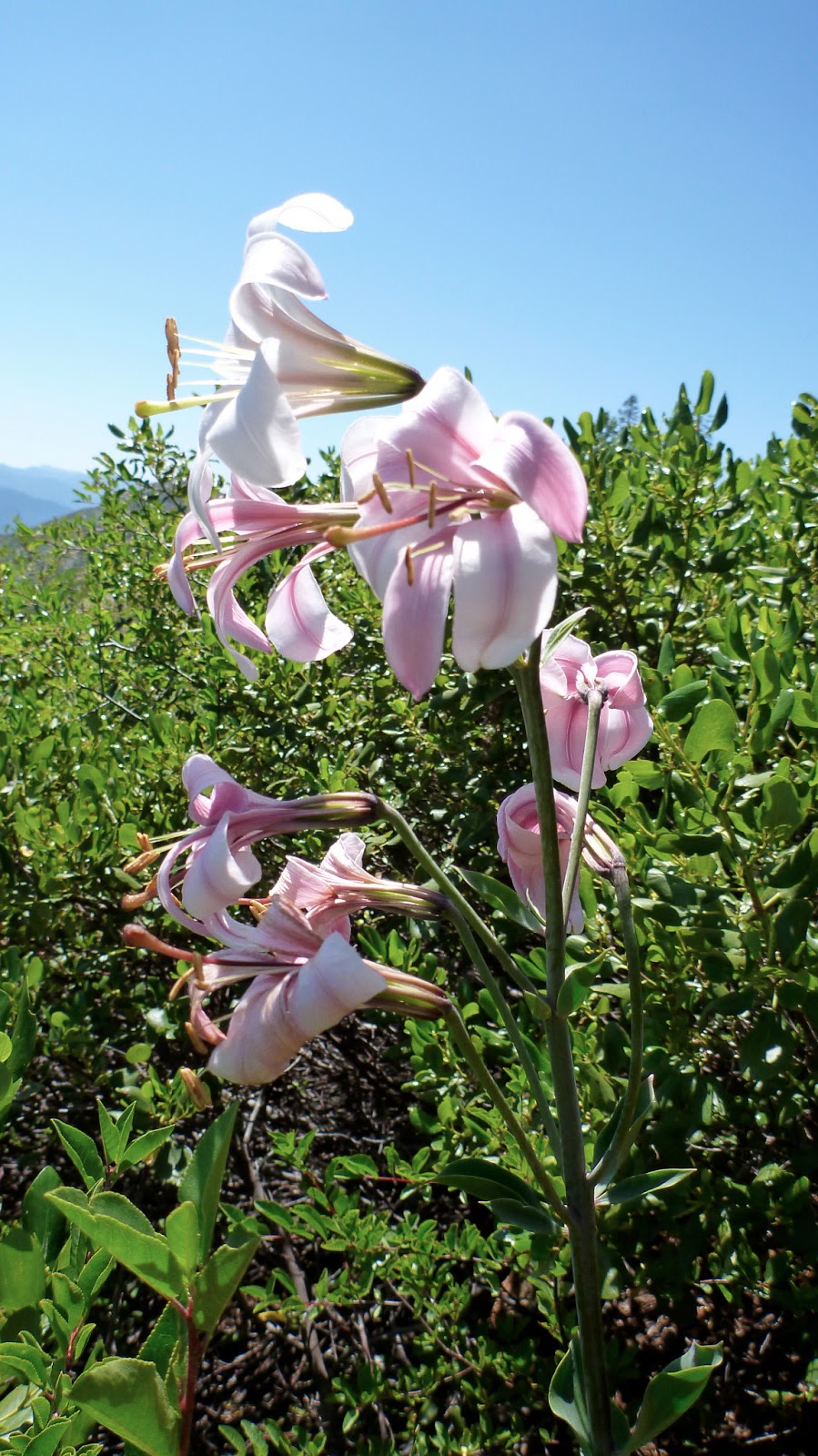 |
| Cascade Lily. What a flamboyant flower for the mountains! |
Dinner at Beardog Spring. Log to sit on, and a great meadow with Cornhusk Lilies tall and blooming all over. We find a lily leaf folded into the braided trickle of the spring and it funnels the water right into our bottles. Beautiful! We sit up on the long log -- and then along comes Bone Lady and Swiss Cheese. We make our Rahmen for dinner and rest a bit. We sit on our jackets, since our butts have lost their fat and even sitting on logs hurts. But what a lovely spot.
Nice camp on sparsely wooded ridge with strong winds - Lavender ridges to northwest with salmon and coral atmospherics as sun sets. Cozy in tents with rainfly against the wind. Sweeet.
 |
| Our tents in a makeshift clearing with amazing views to the west. And wind. |
 |
| Evening views to the northwest from our campsite. |
- Posted using BlogPress from my iPhone
Monday, July 30, 2012
30 July -- Day 90 -- Beautiful Descending
From Three-fork Fir Campsite by Buckhorn Spring (Mile 1640.8) to Seiad Valley RV Park (Mile 1662)
Total PCT Miles Hiked Today: 21.2
Pan here.
Ouch! We got up at 5am under the giant three-pronged White Fir (we are calling it Yggdrasil), and I made mocha lattes in the dark by headlamp while Seano & Dionysus got packed up. Our trail buddy, Tom Sawyer, also was packing. All of us wanted to reach the Seiad Valley before 2pm when the café in the tiny town closes.
That meant we'd have to pound out 22 miles in 7 hours. Our pace is good but not speedy anymore -- given the fasciitis Dionysis and I are currently struggling with (and, to be fair, even with foot pain Dionysus could zip down the mountain much faster than Seano & I manage). So we set off -- and eat no breakfast and take no breaks for seven hours. Hard going - and the heat increased as we descended. [And we are rushing so, we forget to take any photos].
But what beautiful deep forests met us as we went. The tall moss-furry conifers got taller & taller -- and the understory greener and full of ferns and flowers and berries. The voice of the winter wren tinkled and tumbled among the silent pillars. The polished russet skin of the madrone trees caught the filtering sunlight in a glow.
On the road walk into town -- hot hot hot -- next to the river, what blackberries tempted us! Yum! But we couldn't dawdle, since we were running out of time to make it to town food. Signs of NO MONUMENT and STATE OF JEFFERSON sprouted up here and there. Lots of anti-government signage together with conservative political slogans. Odd.
A local stoner (who works doing "trimming" in the marijuana industry) offered to give us a ride as we neared the town.
We made it to the café just in the knick, and ordered hearty sandwiches. Seano had a chocolate shake and I had a root beer float while we waited for our sandwiches. Lots of eating ensued. But Tom Sawyer had fallen far behind and we hadn't seen him for awhile, so we picked up a club sandwich and fries for him from the café. [It turns out once he realized he wasn't going to make it in time, he slowed down and enjoyed the bumper crop of roadside blackberries along the way].
We staggered over to the campground and rested a bit. We had descended more than 4500 feet over the course of 20 miles. Tomorrow it will be an ascent of the same magnitude -- but in just 9 miles, and the slope faces the hot sun. By all accounts tomorrow -- a scorcher according to the weather service -- will start off punishing. But then it's only two and a half days to Ashland, Oregon. Wow. In two days we cross the 1700 mark -- and we'll have less than 1000 miles before us.
So we are camped under the maples on the lawn of the campground -- among about ten other thru-hikers scattered about -- and anticipating an early start. The store-owner next door has made an extra run to Yreka for restocking (apparently about 90 hikers came through during the weekend and (like locusts?) depleted the store's inventory. So we'll revisit the store at 6 am, and have breakfast at 7 o'clock. On the trail by 8?
It'll be getting hot, we reckon.
- Posted using BlogPress from my iPhone
Total PCT Miles Hiked Today: 21.2
Pan here.
Ouch! We got up at 5am under the giant three-pronged White Fir (we are calling it Yggdrasil), and I made mocha lattes in the dark by headlamp while Seano & Dionysus got packed up. Our trail buddy, Tom Sawyer, also was packing. All of us wanted to reach the Seiad Valley before 2pm when the café in the tiny town closes.
That meant we'd have to pound out 22 miles in 7 hours. Our pace is good but not speedy anymore -- given the fasciitis Dionysis and I are currently struggling with (and, to be fair, even with foot pain Dionysus could zip down the mountain much faster than Seano & I manage). So we set off -- and eat no breakfast and take no breaks for seven hours. Hard going - and the heat increased as we descended. [And we are rushing so, we forget to take any photos].
But what beautiful deep forests met us as we went. The tall moss-furry conifers got taller & taller -- and the understory greener and full of ferns and flowers and berries. The voice of the winter wren tinkled and tumbled among the silent pillars. The polished russet skin of the madrone trees caught the filtering sunlight in a glow.
On the road walk into town -- hot hot hot -- next to the river, what blackberries tempted us! Yum! But we couldn't dawdle, since we were running out of time to make it to town food. Signs of NO MONUMENT and STATE OF JEFFERSON sprouted up here and there. Lots of anti-government signage together with conservative political slogans. Odd.
A local stoner (who works doing "trimming" in the marijuana industry) offered to give us a ride as we neared the town.
We made it to the café just in the knick, and ordered hearty sandwiches. Seano had a chocolate shake and I had a root beer float while we waited for our sandwiches. Lots of eating ensued. But Tom Sawyer had fallen far behind and we hadn't seen him for awhile, so we picked up a club sandwich and fries for him from the café. [It turns out once he realized he wasn't going to make it in time, he slowed down and enjoyed the bumper crop of roadside blackberries along the way].
We staggered over to the campground and rested a bit. We had descended more than 4500 feet over the course of 20 miles. Tomorrow it will be an ascent of the same magnitude -- but in just 9 miles, and the slope faces the hot sun. By all accounts tomorrow -- a scorcher according to the weather service -- will start off punishing. But then it's only two and a half days to Ashland, Oregon. Wow. In two days we cross the 1700 mark -- and we'll have less than 1000 miles before us.
So we are camped under the maples on the lawn of the campground -- among about ten other thru-hikers scattered about -- and anticipating an early start. The store-owner next door has made an extra run to Yreka for restocking (apparently about 90 hikers came through during the weekend and (like locusts?) depleted the store's inventory. So we'll revisit the store at 6 am, and have breakfast at 7 o'clock. On the trail by 8?
It'll be getting hot, we reckon.
- Posted using BlogPress from my iPhone
Subscribe to:
Posts (Atom)